Ground Penetrating Radar (GPR) utility locating in Texas is a highly effective, non-destructive method for identifying underground utilities before excavation begins. GPR technology detects both metallic and non-metallic infrastructure such as PVC pipelines, HDPE conduits, fiber optic cables, and concrete-encased utilities—making it significantly more advanced than traditional locating methods.
In modern construction, infrastructure development, and utility locating, GPR plays a critical role in reducing utility strikes, improving excavation safety, and supporting accurate subsurface utility engineering (SUE).
Because Texas has extensive and complex underground utility networks, GPR is essential for reducing project delays, preventing costly utility damage, and improving excavation accuracy. A single utility strike can cost thousands of dollars in repairs, downtime, safety incidents, and regulatory complications, making accurate subsurface mapping a critical component of any excavation project.
Safe excavation practices are strongly supported by federal safety guidelines. The Occupational Safety and Health Administration (OSHA) emphasizes excavation planning, hazard identification, and utility verification before digging to prevent serious incidents:
OSHA’s Underground Installations Standard also requires employers to determine the estimated location of underground installations before excavation begins:
At Adler, these principles align directly with our approach to utility locating services.
Texas presents unique challenges for underground utility locating, including:
Because of these challenges, GPR utility locating is often the first step—but not the final step—in a safe excavation workflow.
Contractors are required to contact Texas 811 before digging to identify public utilities and reduce excavation risks:
However, 811 does not locate private utilities, which is why contractors often rely on advanced solutions such as Adler’s GPR utility locating services and hydro excavation services for complete subsurface visibility.
Ground Penetrating Radar operates by sending high-frequency electromagnetic waves into the ground. When these waves encounter changes in material density—such as pipes, cables, conduits, voids, or buried structures—they reflect back to the receiver and are processed into a visual subsurface map.
GPR systems typically include:
Higher-frequency antennas provide detailed shallow imaging, while lower frequencies allow deeper subsurface penetration for large-scale infrastructure mapping.
For projects requiring precise utility confirmation, Adler often pairs GPR with vacuum excavation services for utility exposure and verification.
According to the Federal Highway Administration (FHWA), Subsurface Utility Engineering (SUE) combines engineering practices and advanced utility detection technologies to improve project planning and reduce utility conflicts.
GPR plays a critical role in SUE by helping identify:
When combined with utility verification and hydro excavation, GPR provides a more complete picture of underground conditions and helps reduce excavation-related risk.
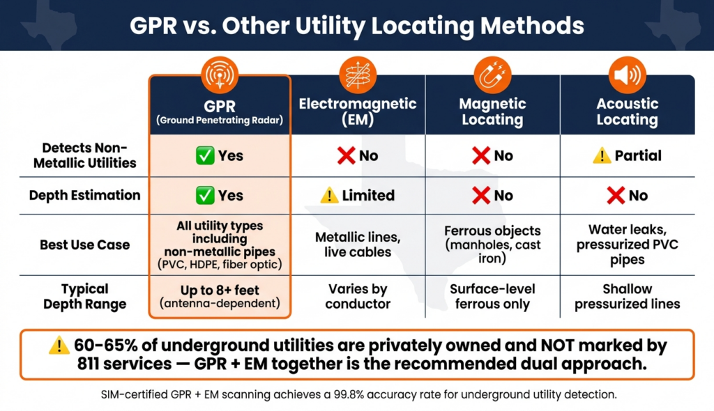
Compared to electromagnetic (EM) locating, GPR offers a broader detection range:
This makes GPR especially valuable in Texas, where many underground systems include plastic and composite materials that EM locators cannot detect.
The Federal Highway Administration recognizes GPR as a key complementary technology for subsurface utility engineering and utility risk management.
Adler integrates these methods through on-site industrial solutions and multi-technology locating workflows.
Soil composition significantly impacts GPR effectiveness across Texas.
Common in portions of West Texas and Gulf Coast regions, sandy soils typically provide:
Common throughout North Texas and DFW regions, clay-heavy soils may cause:
Wet conditions increase soil conductivity and may reduce GPR performance.
Contractors can review soil characteristics through:
Because of these limitations, GPR is often combined with EM locating and hydro excavation for utility verification.
GPR should be used alongside EM locating for full detection coverage.
Physical verification is required in high-risk areas using vacuum excavation services.
Always notify 811 before excavation to ensure public utility marking.
Proper training improves interpretation accuracy and reduces utility locating errors.
GIS mapping, CAD drawings, and utility records improve long-term infrastructure management.
GPR is widely used across multiple industries:
Adler supports these industries through municipal sewer maintenance, storm drain system care, and on-site industrial solutions.
Commonly detected underground infrastructure includes:
Many utility strikes occur because private infrastructure remains unmarked after an 811 request.
Private utilities may include:
By identifying private utilities and undocumented infrastructure before excavation begins, contractors can significantly reduce utility damage risk and improve excavation safety.
The Common Ground Alliance (CGA), a leading authority on utility damage prevention, promotes comprehensive locating practices that include both public and private utility identification.
GPR is best used for non-metallic utilities such as PVC, HDPE, concrete encasements, or fiber optic lines that EM locators cannot detect.
Accuracy depends on soil type. Clay-heavy and saturated soils reduce signal clarity, while sandy soils improve penetration. GPR is often combined with EM locating and hydro excavation for best results.
Yes. Hydro excavation is used to physically confirm utility location, depth, and condition before excavation begins.
Yes. GPR is highly effective for identifying many private underground utilities that are not included in standard 811 markings.
Utility verification confirms the exact location and depth of underground infrastructure, helping contractors avoid utility strikes and improve excavation safety.